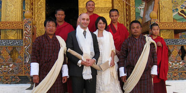
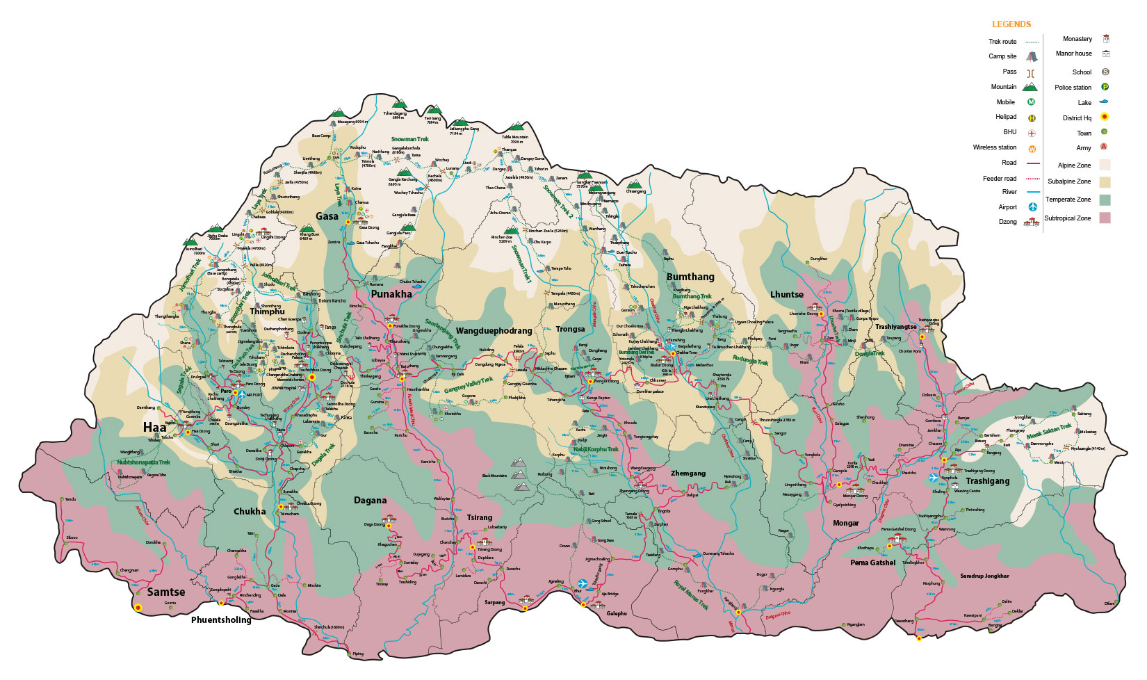
Laya-Gasa Trek
17 Days 16 Nights
Trek Facts
- Dificulty Level:

Hard  Duration:17 Days 16 Nights
 Altitude: 4,220m
 Season: : April to June & Mid September to Early Nov
 Group Size: 1 pax & above
 Trip Starts: Drukgyel Dzong (Paro)
 Trip Ends:Zamina (Punakha)
Attraction
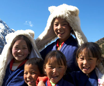
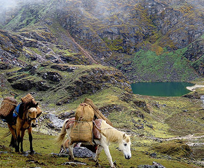
There will be lots of opportunities to interact with the friendly Nomadic people on the trek and also can visit few of their houses. Some beautiful Bhutanese mountain villages, the unique culture and appearance of the Layaps (people of Laya district) and finally a day of relaxation at the Gasa hot springs add to an extremely rewarding trekking experience.
Package Includes
3-star plus hotel accommodation, three meals a day, SUV/mini bus/coaster, guides, trekking gears, camping equipments, entry fees, mineral water, cultural program (in groups of 10 or more people), & taxes
Package Excludes
Air tickets, travel insurance, drinks, visa fee & laundry
Video
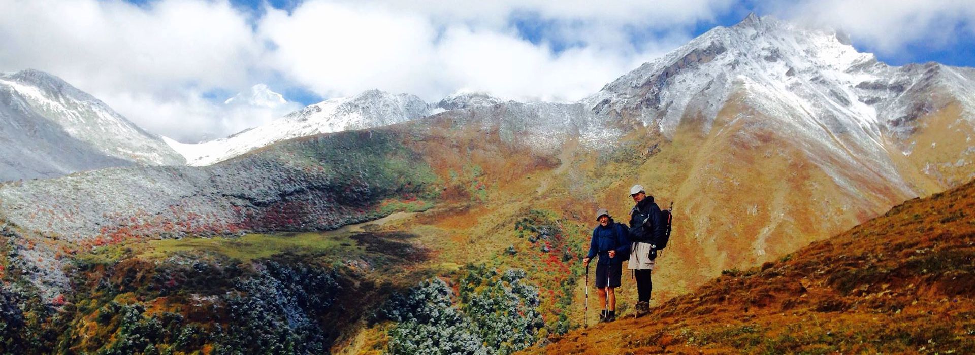
This trek allows the trekkers to enjoy the taste of the real trek in Bhutan with variety of Bhutanese landscape, stunning Himalayan views and very few nomadic settlements and pristine environment which very a few countries can boast of.
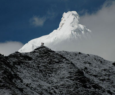
This is one of the most popular trek in Bhutan due to its easy access, beautiful terrain and spectacular views of the majestic snowcapped mountains and beautifully located campsites. All in all, the Laya Gasa Trek is considered to be the most beautiful trek of Bhutan, only to be beaten by the tough Snowman Trek. Besides the unforgettable and majestic views of Mount Jomolhari, the trek offers spectacular views on Jichu Drake, Gangchhenta (Great Tiger Mountain). Between Jangothang and Laya the trail hardly goes below 4,000m and one has good opportunities to spot blue sheep, takin, Himalayan marmot and also elusive Snow leopard.
Detailed Itinerary
Day 01. Bangkok to Paro
The breath taking flight into Bhutan takes you over the great Himalayas, offering you the most scintillating scenery of the world's highest mountain peaks. As you enter Paro valley, you will see pristine and clear Pa Chu (Paro river) meandering down the valley, and just above the town on the upper bank of pachu you will see prominent Paro Rimpung Dzong (fortress) which houses the District headquarters and Ta Dzong (Watch Tower). Just above the Dzong which now houses the national Museum of Bhutan.
Without wasting much time after your arrival in paro International Airport, we will drive to town for a short stroll just before lunch and then visit Paro Museum for a great introduction to Bhutan. A tour to Bhutan would be incomplete without a visit to the museums. JICA always prefer to do the museum first since nothing introduces you to Bhutan better than Paro Museum .It gives you clear picture of Bhutan and what you can see during your stay in the land of thunder Dragon. Then we walk down to paro Dzong that is the seat of local government in Paro and also houses monk body. A part of Little Buddha was filmed here in this Dzong.
Before checking in to hotel if time permits and also if you still have some energy left, we will visit kyichu Lhakahng build by the Tibetan King Songtsen Gampo in 647 A, D that is considered one of the most important and sacred temple in Bhutan. It is also considered as the oldest. Brief orientation and welcome drinks just before dinner. Hotel (D, B)
Day 02: Paro - Takstang hike
We have always done taktsang on the second day to acclimatize just before trek. It gives us a feel of the altitude if you have flown in straight from sea-level a day earlier when we hike to altitude of 3000 meters .we will be making a pilgrimage to one of the most important and sacred religious sites in the Himalaya, Taktsang Lhakhang, known as the Tiger Nest. It is a whole day affairs with the hike and the visit to numerous temples. This magical monastery clings to a vertical granite cliff 2,000 feet above the valley floor. The legend of Taktsang (Tiger’s lair) dates back to 747 AD when Guru Rinpoche (Padmasambhava), in the wrathful form of Guru Dorji Droloe, is believed to have arrived at the site on the back of a tigeress and subdued the evil spirits in the region. The Guru then meditated in the holy cave, which is the site of the Pelphug Lhakhang today. According to tantric Buddhist mythology, the vanquished local deities became the protectors of the dharma and one of them, Singye Samdrup, is recognized today as guardian deity of Taktsang.
Guru Rinpoche is also believed to have concealed among the rocks of the Taktsang various forms of Dharma treasures known as Ters, that were destined to be discovered later by Tertons (treasure discoverers) for the propagation of dharma.
As you may have heard, Taktsang was severely damaged by fire on Sunday, April 1998.His Majesty the King commanded the restoration of Taktsang monastery soon after the fire. It was a royal command that the original aura, authenticity, and architecture splendor must be preserved at all cost. The project was immediately mobilized to restore that monastery and to preserve and strengthen Bhutan’s unique spiritual heritage. The project has been widely seen as an act of devotion, involving all section of Bhutanese society, and homage to the nation’s heritage. It also proved to be an opportunity for Bhutan’s traditional artists and craftsmen to hone the skills inherited from their forefathers down the ages.
To facilitate the restoration work, a road was built to the base of the mountain facing the temple. We will drive to the end of this road and begin our hike up the mountain for a closer view of the temple. In approximately one hour, we will reach a small teahouse that has a wonderful panoramic view of the temple. After having blessed tea and also since we have been energized by tea and rest we will continue for another hour to taktsang. None of the tourist has ever complaints about this hike. It has been rated as one of the most beautiful hike tourists have done with the visit to taktsang temples.
Day 03: Drukgyal Dzong to Shana (15 km, 6 hours)
Drive up to Drukgyal Dzong (2,580m) where the road ends and the trek begin. We walk along a dirt road for one hour through a wide, rich, cultivated valley where people grow paddy. Wheat, potatoes and some millet and also grows some apples which they export to Bangladesh. The trail follows the Paachu and we can hear Pachu roaring down hill if we do the trek right after monsoon.
At Tshento (Chang Zampa) there is a small shop and a BHU. High up to the right cliff is a retreat centre, the Chona Gompa (11,430ft/3,485m), where normally old and senior monks come for meditations. We will come across a lot of beautiful traditional Bhutanese farmhouses with bright red chilies drying on their roofs in season.
At the end of the dirt road a new suspension bridge was built few years ago (8,150ft/2,485m). The trek continues on the east side of the river. The trail climbs gently and will probably be muddy for some time. After walking for two to three hours just before entering a forest again we come across another chorten (8,450ft/2,577m), where we normally serve lunch but if the spot is occupied or if we arrive early we can walk further up for another half an hour and have in a beautiful meadow.
After two and half hours we will arrive at Royal Bhutan Army camp with welcome to Gunitsawa sign painted on a huge boulder. The camp has a school for the children of soldier and also for the locals and some shops. At the army your gate trekking permit will be checked.
From the army camp you can see a ridge coming down from the northeast. This is the route for descending from the Jhomolhari Soi Yaksa trek, which begins and ends in Drukgyel Dzong. After crossing Pachu on a new footbridge, turn straight to the north-northwest following a trail next to the river, which climbs for 15 minutes. And then after another 10 minutes through forests, we will arrive at the campsite in a big open field at Shana or camp beside paachu on a small meadow. Camp – Shana (2,850m)
Day 04: Shana – Thangthangka (22 km, 8 hours)
Since it is a long and hard day with a lot of distances to cover, we will start early so that the clients can take their own paces. The altitude gain is more than 2,000 feet today and we need to trek gently. Follow the river upstream on its right side on a muddy trail. After 15 minutes, we will come across an old ruined bridge (Shana Zampa, 9,440ft/2,878m) destroyed by floods caused by glacial lake outbursts in late 1950.
After going uphill through the river valley, you enter the Jigme Dorji National Park. The Trail climbs steadily through a beautiful thick forest of Blue pine, Oak, rhododendrons, bamboo and ferns. After crossing a couple of small streams and walking for two and half hours we arrive at Shing Kharap (10,170ft/3100m) where we have two shops where they sell Chinese beer and home-brewed beer and some whiskies too.
Not far from Shing Karap, the trail forks, the one that goes straight is the trail to Tibet and one that slopes down to right is the way to the way to our camp. After trekking for 5 hours we will have lunch at a small meadow next to paachu. The trail gradually ascend till we reach our camp .Two hours from the lunch spot we will arrive at a chorten on the other side of the paachu, if the weather is clear we can have a fantastic photo of Choeten and Jhomolhari at the back drop. After a good photograph of the choeten and Jhomolhari, we will cross the river again and walk gently for 20 minutes before we reach our camp. If you follow the other trail across the river, it leads to village of Soi Yaksa . Camp: Soi Tangthangka (3,610m)
Day 05: Thangthangka to Jangothang (17 km, 6 hours)
If you did not see Mount Jhomolhari the previous evening, you will have a chance to get a great view this early morning. This morning, the trek continues up the Pachu valley that widens into patches of alpine meadows teeming with flowers in seasons. After half an hour trek from the camp on the right hand side of the path in late may, you can see few blue poppy (Bhutan’s national flower) in bloom.
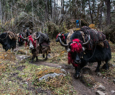
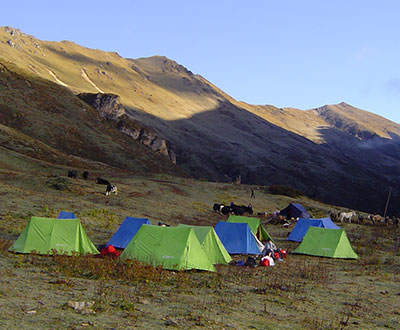
At (12,235ft/3730metres at a place called Soe Makhang, a military camp with Bhutanese and Indian army personnel are stationed has a helipad, and guards another pass into Tibet, 11Km away from Phari. After crossing an army outpost the trail gradually ascends till we reach Jangothang base camp. Yaks and the Nomads’ homes become a regular feature of the landscape. We will be passing the villages of Soe and Thangthangka before reaching Dangochang where we have a small BHU. Jangothang is one of the most beautiful campsites in the Himalayas and you will be treated to a spectacular view of Mount Jhomolhari. Camp – Base Camp (4,080m)
Day 06: Halt at Jangothang Base Camp
The day in Jangothang provides plenty of possibilities for day hikes with great views on lakes and snow capped mountains such as Jhomolhari and Jichu Drake. There are good chances to spot some blue sheep on the upper slopes of the valley. Jangothang is a perfect place for your acclimatization. You may hike to Tsophu that takes you around 3 to 4 hours with again stunning views of Jomolhari and Jichu drake. There are good short hiking trails in three directions. Jhomolhari and its subsidiary mountain chains lay directly west, Jichu Drake to the north and a number of unclimbed peaks to the east. Or you may just relax and enjoy sun n fantastic view of Jhomolhari. Camp: Jangothang
Day 07: Jangothang base Camp to Lingshi (21 km, 8 hours)
Initially the trail gently follows the glacial fed stream through Yak herder’s village for half an hours before crossing a bridge to the right side. From the bridge the ascend is rapid at least for an hour and then becomes a gradual ascend to the Nyilila pass at 4,870m. As you ascend, you might see herds of blue sheep grazing on the slopes of the mountains.
From the pass, you will have spectacular views of Mt. Jhomolhari, Jichu Drake and Tsherimgang, all of them rising above 7,000m. On the way down to the camp you will pass by some of the yak herder’s tents, made from yak wool, where the herders take shelter while on the move to various pastures for their yaks in winter. As you come down into the Lingshi basin, on a clear day you get a wonderful view of Lingshi Dzong. Tserimgang and its glaciers rise up at the north end of the valley. The campsite is next to a stone hut just before you reach Lingshi Dzong. Camp – Lingshi (4010m).
Day 08: Lingshi – Chebisa (10 kms, 6 hours)
Today is the shortest walking day, and you can really take it easy. Shortly after starting you will reach a chorten below Lingshi Dzong. Here, you have the choice of staying on the main trail or taking a diversion up to the Lingshi Dzong (4,220m), which sits right atop a ridge. Besides a very special atmosphere of mystic silence Lingshi Dzong provides a great view over the valley.
After Lingshi Dzong you will be passing the villages of Lingshi and Goyul. In Goyul, the stone houses are clustered together to a small compact village that is unusual in Bhutan where village houses are normally scattered. On reaching the campsite at Chebisa with a beautiful waterfall behind the village, you will have plenty of time to visit the village houses if you feel up to it. Camp: Chebisa (3,880metres)
Day 09: Chebisa – Shomuthang (17kms, 7 hours)
You walk through a wide pastureland towards Gobu La (pass). On the way, you will see a few people herding yaks. There is also a great chance to spot large herds of blue sheep above the trail. After crossing the Gobu La (4,410m), you descend to the valley, then climb again a little bit, and descend again to Shakshepasa (3,980) where a helipad has been established. Climbing from here you will finally reach the campsite at Shomuthang, above a river, which is a tributary of the Mochu. Camp: Shomuthang (4,220m)
Day 10: Shomuthang – Robluthang(18kms , 7 hours )
As the walk is a little strenuous, it is advisable to start early. Climbing up the valley to view Kang Bum (6,526m) and some edelweiss. After two hours of climbing you will reach Jhari La (4,750m), from where you catch the first sight of Sinche La, the pass you will have to cross the day after. The big snow peak in the north is Gangchhenta 6,840 m, better known as the Great Tiger Mountain. If weather is clear, Tserim Kang and the top of Jumolhari will be visible. The camp by the river is called Tsheri Jathang. Herds of takin, the Bhutanese National Animal, migrate to this valley in summer and remain for about four months. The valley has been declared a takin sanctuary. Climb up a little bit and you will reach the campsite at Robluthang in a rocky meadow. Camp: Roblutahng (4,160m)
Day 11: Robluthang – Limithang (19kms, 7hours)
After crossing Sinche La (5,005m) – the last and highest pass on the trek in case you don’t intend to continue the Snowman trek from Laya onwards – you descend to a little stone house where a few Laya women – dressed in typical Laya costume with long pointed bamboo hats on their head – live and offer their weaving products. Right behind the stone house you will see an impressive terminal moraine and a glacial lake at the foot of the valley. You can see classic examples of the lateral moraines where the glacier has pushed rocks up both sides of the valley. Below the moraine, you cross the Kango Chhu and soon reach the Limithang campsite. The peak of Gangchhenta towers over the campsite even though it’s quite a distance away.Camp: Limithang (4,140m).
Day 12: Limithang – Laya (10kms, 5 hours)
Today, you walk all the way downhill along a narrow winding river valley. After a long time, you again trek partly through deep forest. The trail leads you to the west side of Laya village. From the west of the village you will view Gangchhenta again and catch a glimpse of Masagang. In the village centre is a community school and a basic health unit with telephone connection. The campsite is below the school. Camp: Laya (3,840m).
Day 13: Laya – Koina (19kms, 7 hours)
The trail winds up and down along the river valley of Mo Chhu avoiding natural obstacles and affording breath-taking views of the crashing river, feeder streams and water falls. Lots of ups and downs will lead you to Kohi Lapcha at 3.300 m. The trek then drops down to the large stream of Koina Chhu, where you will find the campsite of Koina.Camp: Koina (3,050m).
Day 14: Koina – Gasa (14kms,7 hours)
Today you will have your last major climb of the Laya Gasa Trek. You will cross the Bari La (3,740m), after which the trail is all the way down till you reach Gasa village (2,770m), where you will find the first restaurants since starting from Drukgyel Dzong. There also is a campsite close to Gasa Dzong (. You will have to decide if you want to stay in Gasa village or descend for another one hour to the Gasa Tsachu (hot springs) and relax in the thermal water.
The Gasa Tsachu is one of the most popular hot springs in Bhutan.The hot spring has been recently destroyed by flash flood of 2010 and the construction and development activities of the hot spring area is still going. The Gasa Dzongkhag says it will at least take a year or two to complete this project. Camp: Gasa Tsachu (2,240m).
Day 15: Gasa – Damji to Punakha (3-12kms, 1-4 hours)
After a short climb, the trail winds through lots of ups and downs, through rolling hills and passes and pine and oak forests, villages and wheat fields. You will also see a beautiful view of the Gasa Dzong glued to the valley wall as if floating in space. Today the road has reached Zamina, leaving a gap of about an hour’s walk from dzong to the dirt road head.
Although the road had reached Zamina in 2010, it was closed for traffic because of roadblocks from mudslides and also the road is not set properly. So in monsoon we will have to trek to Gezapang, which is about a four-hour-walk from Gasa.
You finally reach Damji where our bus driver and a staff welcomes us back to civilization with khaddar and with tea and snacks n some bottles of beer and juices for us. From damji we drive on a dirt road for an hour to Tashithang and then for another hour to Punakha .The trail descends from the high agricultural fields above the Mo Chhu into a lush semi-tropical gorge filled with banana trees, creepers and other tropical vegetation. You will also see monkeys and a few other animals like barking deer occasionally. Visit the Dzong in before lunch
Day 16:THIMPHU TO PARO (56kms, 1 ½ hours)
You will have a full day to explore the attractions in and around Bhutan’s capital, Thimphu. As Bhutan’s largest city, with a current population of approximately 120,000, Thimphu is Bhutan’s “Big Apple”! It is the seat of the Royal Government of Bhutan, the home of the Royal Family and the main center for most international aid organizations. As the only true “city” in Bhutan, it is a unique mix of Himalayan and Western sensibilities.
You will begin your exploration with a visit to the Bhutan Heritage Museum. This wonderful museum, which officially opened in July of 2001, provides an opportunity to step inside a typical Bhutanese household and experience first hand the intimacy of daily life in Bhutan. It features utensils used in farming as well as those used in cooking, religious ritual and everyday life.
After this stop, you will continue exploring Bhutan’s culture and traditions with a stop at the new Textile Museum. Cultures around the world have developed ways of producing cloth, and Bhutan's textiles are unique for their diversity and sophistication. The Textile Museum explores this dynamic craft. The ground floor introduces the skills of spinning and coloring fibers, preparing a loom, and the everyday uses of textiles for such things as clothing, ceremony, blankets and other utilitarian functions. The upper floor illustrates the diversity of Bhutan's textile arts, and contains special exhibits featuring regional garments, as well as masterpieces produced by local Weavers. You will have time to see other sights in and around Thimphu as well. Depending on your interests, some of the sites that may be included are:
Day 17: PARO TO BANGKOK
After early breakfast in the hotel, drive to the airport for flight to onward destination.
NOTE: -Some time itinerary may subject to change depend up on situation and coincidence. This is for your kind information & necessary consideratio